description
Jeffreys, Thomas
Jeffreys began his career as a copper engraver, becoming an apprentice to Emanuel Bowen in 1735, but increasingly turned to geography and map publishing, eventually becoming one of the leading map suppliers of his era. He was appointed “Geographer to the Prince of Wales” in 1746, and later to the King. The titles indicate that Jeffreys was seen as a reputable publisher with a sufficiently large collection of maps to fill the prince’s, or king’s, personal needs. They did not represent an official position sanctioned and salaried by the government. Government agencies used a variety of commercial cartographers to publish maps. While his focus was primarily the New World and Great Britain, he also created maps for Gentleman’s Magazine 1746–1757, and collaborated with Thomas Kitchin, Laurie & Whittle, and others on regional/world atlases. Of particular interest to this
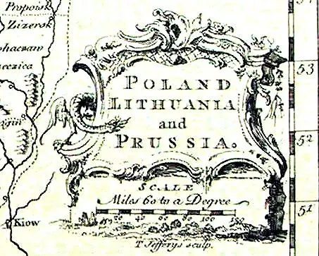
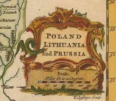
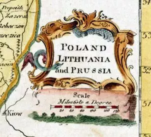
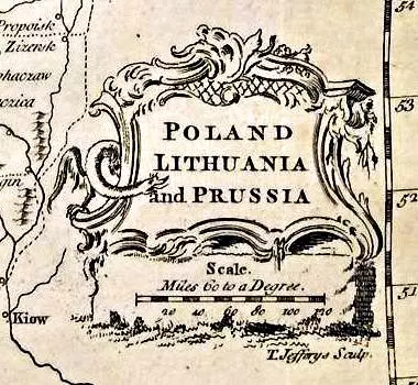
site, he engraved a map titled “Poland Lithuania and Prussia” for the first, 1749, edition of “The/A new geographical and historical grammar…” by historian Thomas Salmon, commonly said to have gone through 14 editions through 1785. I have researched information at the Villanova University Library, the New York Public and British Libraries, various auction houses who had images of the title pages of editions, and Barbara Backus McCorkle’s 2009 “A Carto-Bibliography of the Maps in Eighteenth Century British and American Geography Books” (not perfect: the 1771 Edinburgh edition is actually titled “A new geographical…” not “The new…” as she states), and I now believe there were at least 21 separate editions, the last in 1785. The only changes in that plate over 36 years were to the cartouche, which I now believe exists in four versions:
A. no vertical hatches; “T. Jeffreys sculp.” centered; “and” is on a separate line;
B. vertical hatches; “T. Jeffreys sculp.” to the right (from the last and most worn plate);
C. no vertical hatches; “T. Jeffreys sculp.” erased from plate;
D. no vertical hatches; “T. Jeffreys sculp.” to the right.
The First, 1772, Partition of the Polish Lithuanian Commonwealth was ignored in four separate new editions. There is no way to confirm the publish date of a particular version of this map without having seen the title page of the edition it came from. Below is the history of this map’s editions titled either “The new-” or “A new geographical and historical grammar…” I have not included in this summary Salmon’s “gazeteers” or his “The new universal geographical grammar…”
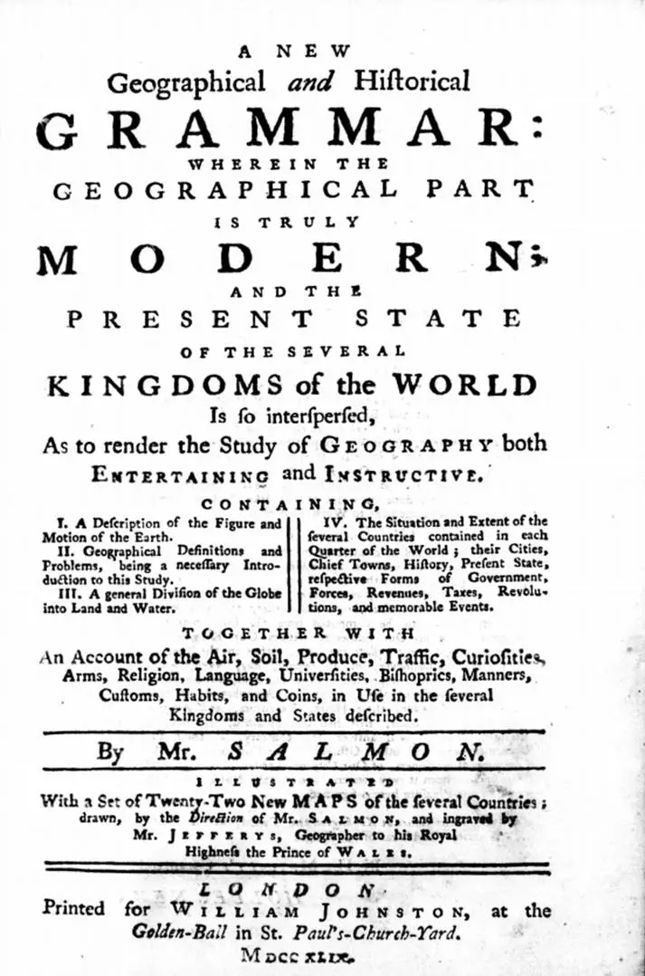
- 1749: “1st edition”, London: “A new geographical and historical grammar…”
- 1751: “2nd edition”, London: “The new geographical and historical grammar…”
- 1752: “3rd edition”, Dublin: “A new geographical and historical grammar…”
- 1754: “3rd edition”, London: “The new geographical and historical grammar…”
- 1756: “4th edition”, London: “The new geographical and historical grammar…”
- 1757: “5th edition”, London: “The new geographical and historical grammar…”
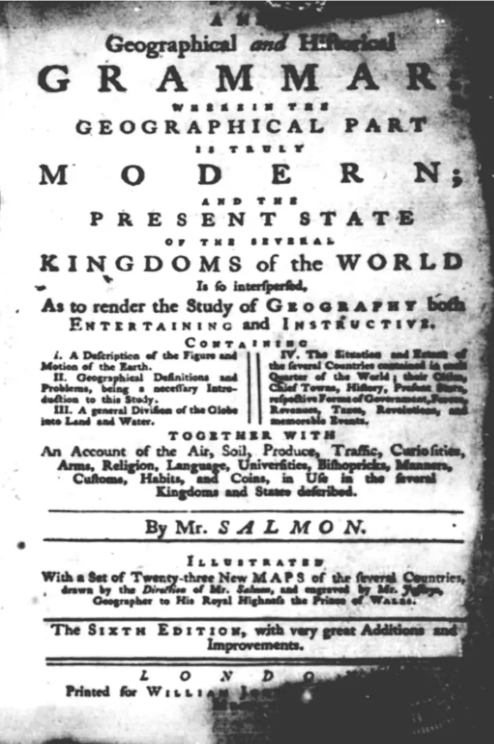
- 1758: “6th edition”, London: “A new geographical and historical grammar…”
- 1760: “7th edition”, London: “The new geographical and historical grammar…”
- 1760: “9th edition”, Dublin: “A new geographical and historical grammar…”
- 1762: “8th edition”, London: “The new geographical and historical grammar…”
- 1764: “9th edition”, London: “The new geographical and historical grammar…”
- 1766: “10th edition”, London: “The new geographical and historical grammar…”
- 1766: “12th edition”, Dublin: “A new geographical and historical grammar…”
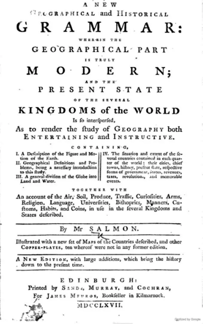
- 1767: “New edition”, Edinburgh: “A new geographical and historical grammar…”
- 1769: “11th edition”, London: “A new geographical and historical grammar…”
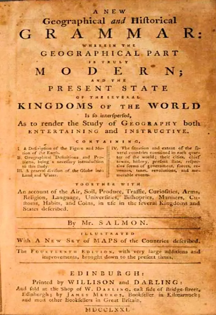
- 1771: “14th edition”, Edinburgh: “A new geographical and historical grammar…”
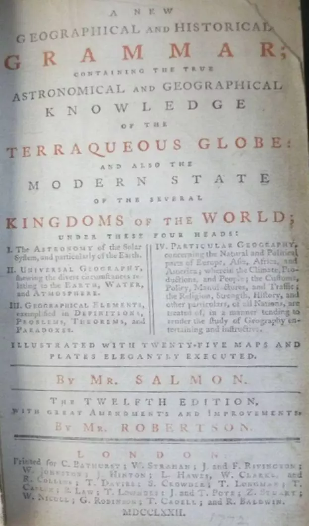
- 1772: “12th edition”, London: “A new geographical and historical grammar…”
- 1777: “New edition”, Edinburgh: “The new geographical and historical grammar…”
- 1778: “1st edition”, Edinburgh: “The new geographical and historical grammar…”
- 1780: “New edition”, Edinburgh: “A new geographical and historical grammar…”
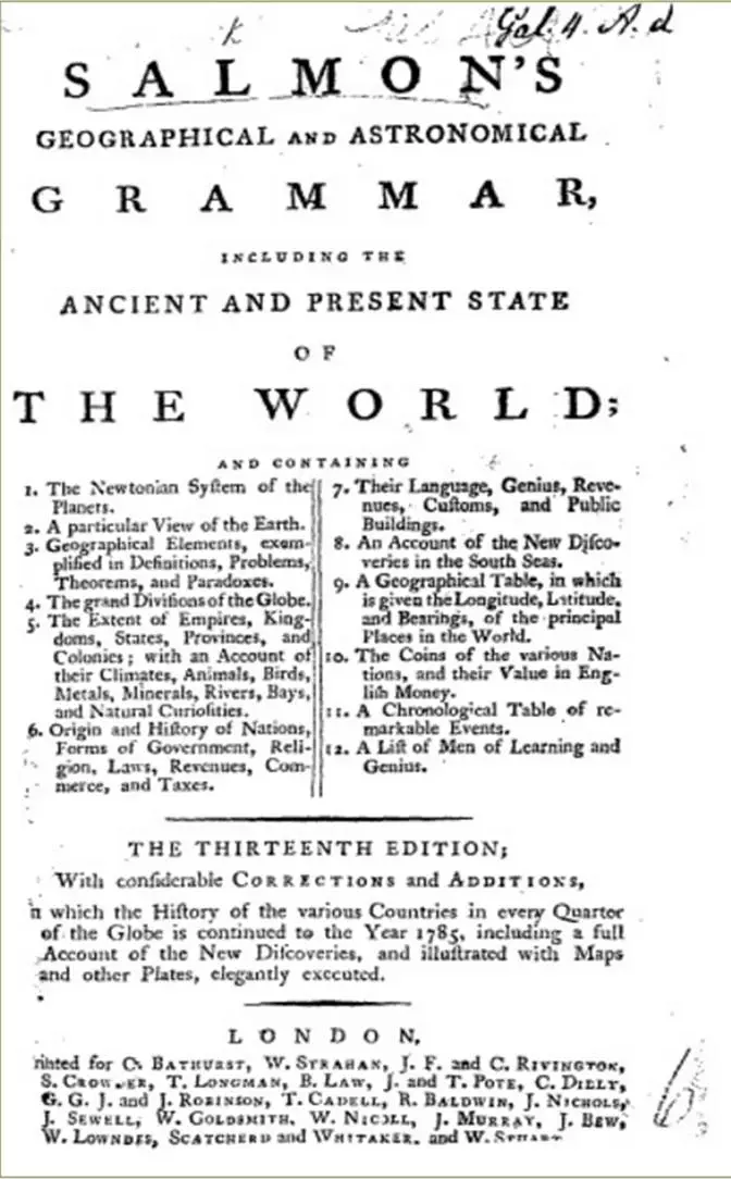
- 1785: “13th edition”, London: “Salmon’s geographical and astronomical grammar…” Yes, a different title, but the 13th London edition, nevertheless, according to the title page, with the very same map!
What I found, in reconsidering the 19 different images of this map on my site, was that a number of dates given by sources for their maps was wrong: there could not be two different cartouche types in the same edition. My misgivings – and plate type for each image – are now (12/10/16) on this site. In addition, I found one map, from 1782, misattributed to Thomas Kitchin instead of to Thomas Salmon. Why can’t I, now that I’ve verified the editions, assign a particular cartouche
type to London, Dublin or Edinburgh, or to a timespan? Because this map is twice-folded in the little atlas, and, more often than not, the clerks at the British Library did not bother to scan the complete map – the cartouche, on the extreme right side, was most often only partially scanned. Auction houses selling the entire volume(s) did not choose the map of Poland Lithuania and Prussia to reproduce. Go figure. Maybe next time I go to the British Library?
Dates
1710–1771
Place of birth
London